In competitive industries such as shipping, commercial transportation and public transit, it’s crucial to know where the vehicles in your fleet are at all times. With NetTrack mapping and GPS fleet tracking software, you can track your vehicles’ exact locations, routes, and arrival and departure times, so that you can better manage your services and schedules. Running a smart business requires these advanced tracking systems and solutions, allowing you to closely monitor your company’s employees, vehicles and inventory.
Track Your Truck’s NetTrack GPS fleet management software uses Google Enterprise Edition Maps, which provides the most accurate technology and reliability. Our mapping software is available for Apple iOS and Android systems and offers around-the-clock mapping capabilities from anywhere on any internet-enabled device. Combine with GPS fleet tracking, and you have a robust system for managing your fleet to optimal productivity and efficiency.
NetTrack GPS mapping software helps you adjust routes based on real-time traffic conditions, pinpoint the location of your trucks, and provides more accurate estimated times of arrival.
Track Your Truck GPS fleet tracking with Google Maps offers the most innovative and effective commercial fleet software solutions. Our NetTrack mapping software provides both standard and satellite views, with precise routing technology that’s accurate to within 10-15 feet. You’re able to see color-coded traffic conditions, compare potential routes and zoom in to see a truck’s exact position.
Explore additional benefits of NetTrack With Google Maps including:
Real-Time Traffic Updates – GPS mapping lets you know where your vehicles are in real time. With a clear picture of your service area and each vehicle’s location, you can quickly dispatch the closest service provider when a customer calls. When you can see where your employees are at all times, you can keep them accountable for how they use their vehicles.
Satellite Maps – Advanced mapping shows exact locations along with routes, estimated arrival times and departure times. This more detailed software ensures that you are using your fleet effectively, giving you an instant picture of where your vehicles are and what they are doing. Advanced digital mapping also goes beyond simply displaying where your vehicles are. The right GPS mapping programs will provide traffic updates in real time, so you can route drivers through the most efficient routes, even with variable traffic patterns. You can also use satellite mapping to get a view of the terrain, which can be helpful in off-road applications. With mapping software and GPS powered by Google Maps, you’re able to switch to a satellite map view for a detailed picture of the terrain. Companies benefit from getting an in-depth look at geographical travel conditions such as steep inclines, extreme elevations and other potential hazards.
Google Enterprise – Google Enterprise’s easy-to-use visual data offers the same familiarity as Google Maps, with added features specifically designed for business use. You get 99% reliable coverage of countries and territories worldwide in a secure, scalable platform.

Mobile Tracking – One of the drawbacks of some fleet management software programs is the lack of flexibility. While they allow unprecedented control and the ability to manage your vehicles effectively from one central computer, they do require you to be on the computer. Newer fleet management systems with GPS mapping provide access to mobile apps that let you take the information and data collected through the system on the go and in the field. This means you can manage your vehicles without being tied to the office. In today’s business world where managers are regularly in the field, this is an invaluable addition.
With NetTrack you can break the chains associated with PC-only based software — track your company’s assets using your mobile phone, wherever you go. Our on-the-go fleet tracking app runs on both Apple and Android devices, putting the information you need to optimize your fleet at your fingertips. Verify vehicle locations, perform condition checks on the fly, review vehicle location, and get an overview of all your trucks and their proximity to one another on-demand.
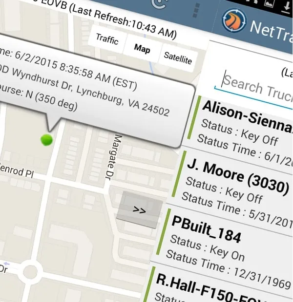
Click Here to See Map Replay Using GPS Detail
Among NetTrack’s features is the Animated Map Replay option that allows you to retrace a vehicle’s route on a map screen for a chosen date and time. The map creates a “bread crumb” trail, allowing you to see the route the vehicle traveled. Each icon has an arrow that indicates the vehicle direction at the time of this particular GPS position. When you click on an icon, a legend box appears. This box provides the time the vehicle was at that GPS location, and the vehicle’s estimated speed, directional heading and street address.
Track Your Truck’s NetTrack mapping solutions come with every GPS tracking device purchase, which is delivered thoroughly tested, activated and ready to track! We are committed to helping you find the best tracking and mapping solution for your business, no matter what industry you serve. From cellular services to pure satellite, or a custom mix of both, there is a tracking system available to help you manage a better business.
When you use NetTrack GPS software mapping and fleet tracking solutions, you’ll get:
Get in touch with us, and we will customize a tracking strategy and system that works for you. Give us a call or submit a form to request a demo or free quote.